Group News & Outreach
![]()
![]()
![]()
2021
May
- Ph.D. candidate, Corey Scheip, publishes an article describing the inner workings of HazMapper, the Google Earth Engine application that he developed for the visualization and mapping of global natural hazard events in the AGU journal Natural Hazards and Earth System Sciences. Read all about here, and then take HazMapper out for a spin!
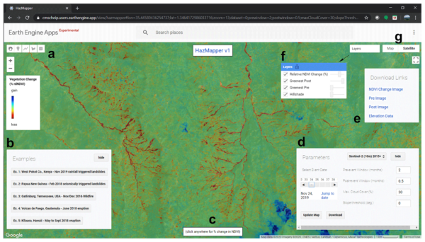
Scheip, C.M., and Wegmann, K.W., 2021, HazMapper: a global open-source natural hazard mapping application in Google Earth Engine: Natural Hazards and Earth System Sciences, v. 21, p. 1495-1511, doi:10.5194/nhess-21-1495-2021.
- New research Reassessing the Tectonic and Earthquake Hazards of the Eastern Mediterranean from the 365 CE Earthquake published in AGU Advances by Dr. Richard Ott (GFZ-Potsdam) and team. We revisit the source mechanism for the largest historical Mediterranean earthquake (365 CE) through radiocarbon dating, fault dislocation, and tsunami modeling. Results support the hypothesis that the earthquakes occurred on normal faults over several centuries (including the 365 CE event) and were responsible for the uplift of the western half of Crete, Greece, by up to 9 m above sea level. The findings suggest a significant earthquake and tsunami hazard from normal faults in the upper plate of retreating subduction zones.
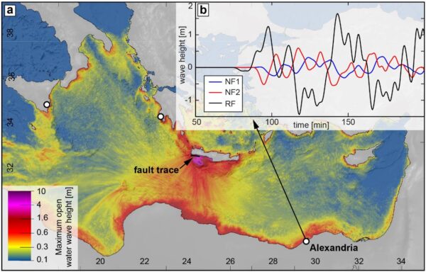
Ott, R.F., Wegmann, K.W., Gallen, S.F., Pazzaglia, F.J., Brandon, M.T., Ueda, K., and Fassoulas, C., 2021, Reassessing Eastern Mediterranean Tectonics and Earthquake Hazard From the 365 CE Earthquake: AGU Advances, v. 2, p. e2020AV000315, doi:https://doi.org/10.1029/2020AV000315.
April
- Thanks to NC State Educational Technology Funds, we have a new Little River Research & Design EM-4 Stream Table in Jordan Hall that will be used for student learning and research efforts in the years to come! If you are in Jordan Hall – come check it out in Room 2121.
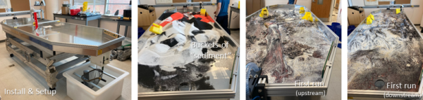
- Check out a short video of the stream table in action here.
- The Ph.D. candidate and group member, Corey Scheip, publishes a single-author paper on the use of lidar water returns to develop more realistic stream channel and topographic models. Read all about Corey’s research in Geomorphology.
March
- Congratulations to Julian Chesnutt, who started a position as the head of the Environmental Subsurface Science Group at Pacific Northwest National Laboratory, Richland, WA.
- Congratulations to Corey Scheip, who successfully passed his written and oral doctoral qualifying exams and has now advanced to candidacy in the Ph.D. program.
January
- In 2020, the HazMapper website recorded 3,379 views from 1,376 unique visitors from 61 different countries. The top-10 countries to visit the website were the U.S., U.K., Canada, India, Germany, Spain, Itlay, China, France, and Austria. Over on Twitter, @HazMapper garnered 116,000+ impressions. #NaturalHazards | #EarthEngine | #OpenAccess | #ScienceDemocritization
2020
December
- Karl presented a class through the Osher Lifelong Learning Institute at NC State University on Seeing the Ground Through the Trees: Using Remote Sensing Technologies for Natural Disaster Research.
November
- Congratulations to Ph.D. candidate Julian (Nuttman) Chesnutt on being awarded a 2021 Dissertation Completion Grant from the NC State Graduate School!
October
- The JavaScript source code for v1.0 of HazMapper, a natural hazards mapping application built-in Google Earth Engine is now available as a Zenodo open-access repository.
- Ph.D. student Corey Scheip presents his HazMapper efforts at the Geo for Good Summit 2020. Hazmapper: A Flexible Geospatial Mapping App for Natural Hazards
- Check out the poster here.
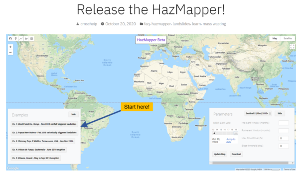
 HazMapper, v.1.0 is now available for public release!
Check out our Google Earth Engine App to identify and monitor global natural hazard events and so much more… The lead developer of HazMapper is Ph.D. student Corey Scheip. Read about HazMapper in our blog, access the App, and start exploring natural hazard events worldwide by visiting the HazMapper website. Share your HazMapper finds with us on Twitter, @HazMapper, and we might turn them into an educational piece on our ‘Hazblog‘ page (with your permission and collaboration, of course).
- Surface Processes & Active Tectonics heads to the 2020 Annual Meeting of the Geological Society of America.
- Check out the research talks presented by group members and affiliated scientists!
- SURFACE DEFORMATION ASSOCIATED WITH THE MW 5.1 SPARTA, NC, EARTHQUAKE
FIGUEIREDO, Paula M. et al. - 144 T137. Advances in Tectonic Geomorphology: Building It up and Tearing It Down
Karl Wegmann1, Emerson M. Lynch2 and Christine Regalla2, - 233-2 EVALUATION OF THE HAZMAPPER GOOGLE EARTH ENGINE APPLICATION FOR COSEISMIC LANDSLIDE MAPPING USING THE MW7.8 2016 KAIKŌURA, NEW ZEALAND EARTHQUAKE AS A CASE STUDY
WEGMANN, Karl W. & Scheip, Corey M. - 240-7 REVISITING THE SOURCE MECHANISM OF THE AD 365 EARTHQUAKE CRETE, GREECE, AND IMPLICATIONS FOR EASTERN MEDITERRANEAN TECTONICS
GALLEN, Sean, et al. - NEW PERSPECTIVES ON A NEW FAULT – HOW THE USE OF DRONES AIDED IN THE CHARACTERIZATION OF THE LITTLE RIVER FAULT
SCHEIP, Corey M, et al.
- SURFACE DEFORMATION ASSOCIATED WITH THE MW 5.1 SPARTA, NC, EARTHQUAKE
September
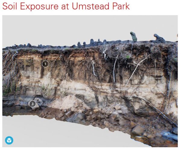
- Delta, the NC State Univesity Distance Education & Learning Technology Applications group, wrote a nice Blog Post on their experience with on-location photo-scanning to create immersive 3D learning and teaching modules. Karl worked with Stephen Waddell and the team to bring field sites out at William B. Umstead State Park into the virtual realm so that students can experience them in a digital, immersive setting. Check out the anthropogenic exposures of millpond legacy sediment in this Sketchfab 3D Model…
June
- Congratulations to Ph.D. candidate Rachel Atkins for being awarded the 2020 North Carolina ArcGIS Users Group (NCAUG) Graduate Student Scholarship recipient for her proposals titled: Investigating the impacts of anthropogenic hillslope modification on landscape evolution using ArcGIS.
![]()
May
- Interested in Paleolithic archaeology of the Aegean Basin and Crete but unsure where to look for those hard-to-find lithic artifacts? Check you this new paper by colleagues from Boston University and me in Quaternary International: Deposit-Centered Archaeological Survey and the Search for the Aegean Palaeolithic: A geoarchaeological perspective; https://doi.org/10.1016/j.quaint.2020.04.043.
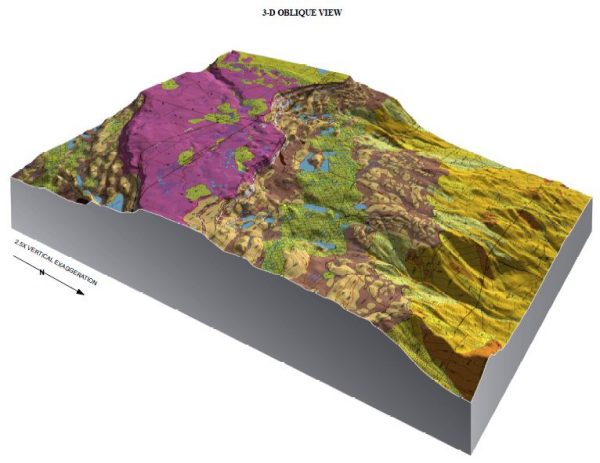
- Ph.D. candidate Julian (Nuttman) Chesnutt published his 1:24,000-scale Geologic Map of the Mesa Lakes Quadrangle, Mesa and Delta Counties, Colorado via the Colorado Geologic Survey as Open-File Map 19-08. The beautiful map and associated data and cross-sections are available for free to anyone interested in the geology of the Grand Mesa. This area contains some of the most spectacular landslide terrains anywhere in the world (I’m biased).
April
- Article by Corey Scheip and Karl Wegmann describing HazMapper is now available for open review and interactive discussion — HazMapper: A global open-source natural hazard mapping application in Google Earth Engine: Natural Hazards and Earth System Sciences, https://doi.org/10.5194/nhess-2020-108.
- Ph.D. student Corey Scheip and Karl Wegmann launch HazMapper.org, a Google Earth Engine application and associated community focused on the open-source and open-access mapping of global natural hazards. Posts highlighting the natural hazard detection capabilities and research applications of the HazMapper platform will be published ~ weekly at our HazBlog. Check out the first two posts on (1) Easter weekend (2020) tornadoes across the southeastern U.S. and (2) December 2019 landslides and debris flows following heavy rains in the Cibitoke Province of Burundi.
March
- Karl was interviewed by Grant Currin of LiveScience.com for an article on How do we tell the difference between geologic ages? Read the piece here.
- Congratulations to Ph.D. student Corey Scheip on the selection of his proposal Utilization of airborne lidar to evaluate regional landslide area-volume scaling relationships after a large rainfall-triggered mass wasting event in western North Carolina by the National Center for Airborne Laser Mapping. NCALM will acquire up to 40-square km of high-resolution lidar topography data in Polk County, NC, supporting Corey’s research efforts.
February
- Del Bohnenstiehl and I updated the NC State Campus Geology Tour with assistance from the Distance Education and Learning Technologies Application (DELTA) staff at NC State to include smartphone-enabled geo-location and interactive technology to bring geological concepts and applications to life for students in the MEA110 (Introductory) Geology lab course. Anyone interested in taking the NC State Campus Geology Tour can access the Seppo.io based application here. In addition, we created an associated Rock Identification app that is available to the public here. Read more about the NC State Campus Geology Tour and Rock ID app on the DELTA Portfolio page.
January
- Karl presented an invited research talk with Ph.D. student Rachel Atkins at the 63rd Annual Meeting of the Soil Science Society of North Carolina on using high-resolution digital topography to predict the location of Piedmont stream channel initiation, with implications for continuing drainage network expansion and stream water quality.
2019
November:
- Karl presented “Geology Underfoot: Exploring the geology of North Carolina as recorded in the landscapes and rocks of Prichard Park at the Explore More session at the Chapel Hill Public Library on Saturday, November 23.
- Members of the Surface Processes & Active Tectonics Lab participated in the NC State University’s GIS Day Open House event at Hunt Library by showcasing our use of aerial drones for geologic hazards research. The full list of events is available here.
- A new Holocene earthquake chronology from Lake Crescent, located on the north Olympic Peninsula of Washington State, is published with colleagues in the Geological Society of America Bulletin.
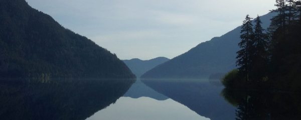
Leithold, E.L., Wegmann, K.W., Bohnenstiehl, D.R., Joyner, C.N., and Pollen, A.F., 2019, Repeated megaturbidite deposition in Lake Crescent, Washington, USA, triggered by Holocene ruptures of the Lake Creek-Boundary Creek fault system: GSA Bulletin, v. 131, p. 2039–2055, doi:10.1130/B35076.1.
October:
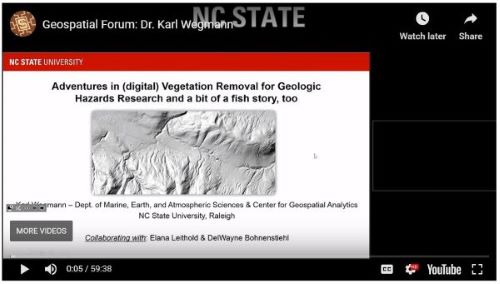
- Karl presented a research talk titled “Adventures in Digital (lidar) Vegetation Removal for Geologic Hazards Research and a bit of a fish story too” on Halloween in the Center for Geospatial Analytics at NC State that includes a discussion of the Holocene paleoseismic record at Lake Crescent, Washington. A recording of the presentation is available for viewing on the Center’s YouTube Channel.
September:
- Congratulations to Ph.D. student Rachel Atkins who was awarded a prestigious Future Investigators in NASA Earth and Space Sciences and Technology (FINESST) fellowship! Atkins was one of only 29 students nationwide chosen for this honor from among nearly 300 students who submitted planetary science proposals. Find out more at the NC State College of Sciences News.